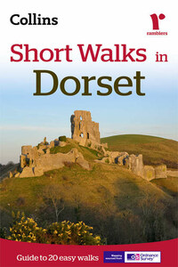
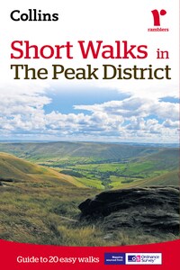
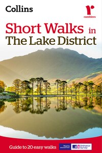
Short Walks in Cornwall
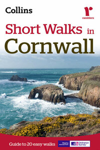
Discover Cornwall like never before with Ramblers Short Walks in Cornwall.This practical e-guidebook contains 20 short walks in Cornwall, all of which are 5 miles or under, and are ideal for families and individuals young and old looking for ideas for an afternoon stroll.Cornwall forms the tip of the southwest peninsula of Great Britain and is home to a fascinating varied landscape, featuring both areas of moorland and coastland. The 20 walks in Ramblers Short Walks will cover each aspect; there is no better way to experience these landscapes.Produced in co-operation with the Ramblers and featuring Ordnance Survey mapping, Ramblers Short Walks in Cornwall is the most reliable and trustworthy walking companion.When you walk with Ramblers Short Walks in Cornwall you’ll enjoy:• 20 easy to follow walks which can be completed in 3 hours and under.• Each walk has a detailed Ordnance Survey map with the route clearly marked plus a detailed description of the route.• The walks have been chosen with consideration for parking and refreshments to ensure they are suitable for families.• Interesting facts about all the things you'll see along the route.• Essential information on walking and the general area covered by the guide.See walk locations and a read preview by Looking Inside.Enhanced ExperienceEnhance your walk with this eBook edition, which has many digital features including:•All content downloaded to device so maps and directions are available at all times.•Never lose your page: click on a walk in the contents to be taken to its page.•Bookmark your favourite walks so you never forget them.
Читать Short Walks in Cornwall онлайн беплатно

Published by Collins
An imprint of HarperCollins Publishers
Westerhill Road, Bishopbriggs
Glasgow G64 2QT
First edition 2011
Second edition 2015
Copyright © HarperCollins Publishers Ltd 2015
Original text © John H N Mason,
David Perrott and Laurence Main
Collins ® is a registered trademark of
HarperCollins Publishers Limited
Mapping on the inner front cover and all walking planning maps generated from Collins Bartholomew digital databases
This product uses map data licensed from Ordnance Survey
© Crown copyright and database rights (2015)
Ordnance Survey (100018598)
All rights reserved under International and Pan-American Copyright Conventions. By payment of the required fees, you have been granted the nonexclusive, nontransferable right to access and read the text of this e-book on-screen. No part of this text may be reproduced, transmitted, downloaded, decompiled, reverse-engineered, or stored in or introduced into any information storage and retrieval system, in any form or by any means, whether electronic or mechanical, now known or hereafter invented, without the express written permission of HarperCollins e-books.
The contents of this publication are believed correct at the time of printing. Nevertheless, the publisher can accept no responsibility for errors or omissions, changes in the detail given, or for any expense or loss thereby caused.
Ebook Edition © March 2015 ISBN: 9780008102050
Version: 2015-04-28
email: [email protected]

Contents

| walk 1: | Crackington Haven 4 miles (6.5km) |
| walk 2: | Boscastle 4 miles (6.5km) |
| walk 3: | Rough Tor 2½ miles (4km) |
| walk 4: | Cotehele & Calstock 4 miles (6.5km) |
| walk 5: | Polperro to Looe 5 miles (8km) |
| walk 6: | Golant 3½ miles (5.5km) |
| walk 7: | Luxulyan 3½ miles (5.5km) |
| walk 8: | Caerhays & Dodman Point 5 miles (8km) |
| walk 9: | Falmouth 2 miles (3km) |
| walk 10: | Lizard Point 5 miles (8km) |
| walk 11: | Gweek 5 miles (8km) |
| walk 12: | Penzance & St Michael’s Mount 4 miles (6.5km) |
| walk 13: | Merry Maidens 4 miles (6.5km) |
| walk 14: | Sennen Cove & Land’s End 4½ miles (7.25km) |
| walk 15: | Cape Cornwall & Levant 5 miles (8km) |
| walk 16: | Men-an-Tol 4½ miles (7.25km) |
| walk 17: | St Ives 3 miles (4.75km) |
| walk 18: | St Agnes to Porthtowan 5 miles (8km) |
| walk 19: | Porthcothan to Mawgan Porth 4½ miles (7.25km) |
| walk 20: | The Rumps & Pentire Point 5 miles (8km) |

walk 1,walk 2,walk 3,walk 4,walk 5,walk 6,walk 7,walk 8,walk 9,walk 10,walk 11,walk 12,walk 13,walk 14,walk 15,walk 16,walk 17,walk 18,walk 19,walk 20

Walking in Cornwall
Cornwall is one of Britain’s principal holiday destinations. The county occupies the most southwesterly part of England, a peninsula bounded to the north and west by the Atlantic Ocean and warmed by the waters of the Gulf Stream to an extent that mild winters allow exotic plants to flourish in sheltered places. The sea is never more than 20 miles away and the coast is the main attraction of the county for most visitors. Inland, both the rugged landscape of moorland and the gentler scenery of woodland, valleys and farmland – as well as the remains of over 5000 years of history – are all worthy of exploration. There could be no better way to experience these landscapes than to follow one or more of the routes in this guide. The walks have been carefully chosen to introduce a cross section of countryside, with a selection of places of interest along the way.
Many of the walks include coastal sections and are well signposted for the South West Coast Path. In its entirety this National Trail runs for 630 miles (1014km) around the peninsula from Minehead in Somerset to Poole Harbour in Dorset. To enable the walker to experience selected sections of this path a few of the walks in this guide are planned using public transport to avoid a return journey on foot. In these cases the suggestion is to park your car at the destination and take the bus to the start point of your walk. Always check bus timetables carefully before setting out. Timetables are available locally and online.
Bus: www.westerngreyhound.com covers the Porthcothan to Mawgan Porth walk, the Penzance and St Michael’s Mount walk and the Polperro to Looe walk.
www.cornwallpublictransport.info and www.hopleyscoaches.com covers the Hopleys Coaches service between St Agnes and Porthtowan.
Train: as part of the St Ives walk www.firstgreatwestern.co.uk has the timetable for the St Ives Bay Line.
Ferry: it is essential to check ahead for the seasonally operated Tamar Passenger Ferry for the Cotehele and Calstock route. The timetable is available at www.calstock-ferry.com
A tide timetable gives details of high and low water at various points so you can plan your walks, beach visits and ferry trips accordingly. A visit to Kynance Cove, for example, will be best at low tide when the rock formations are visible, and if you want to walk the causeway to St Michael’s Mount then it is essential to visit at low tide. Buy a timetable locally in newsagents or garages, or check out times on the Internet.