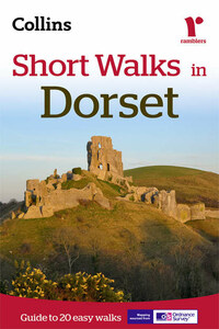
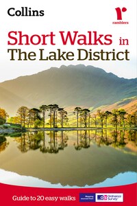
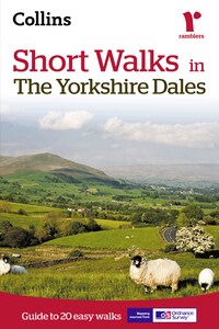
Short walks in the Peak District
Recommended for colour tablets only. This ebook is not suitable for reading on black and white eink devices. All content downloaded to device, making maps and text available at all times.The Peak District, with its gentle limestone White Peak and the wilder more dramatic gritstone Dark Peak, offer some superb walking areas.This guide, produced in co-operation with the Ramblers and featuring Ordnance Survey mapping, is the perfect way to really appreciate the stunning scenery of the Peak District.INCLUDES:• 20 easy to follow walks which can be completed in 3 hours and under.• Each walk has a detailed 1:25 000 Ordnance Survey map with the route clearly marked plus a detailed description of the route.• The walks have been chosen with issues like parking and refreshments in mind to make life easy for families.• Packed with colour photographs of scenes you will see along the walk.The perfect guide for afternoon walks near to Chesterfield, Sheffield, Matlock, Buxton and Macclesfield.
Читать Short walks in the Peak District онлайн беплатно
Short Walks in
The Peak District


walk 1,walk 2,walk 3,walk 4,walk 5,walk 6,walk 7,walk 8,walk 9,walk 10,walk 11,walk 12,walk 13,walk 14,walk 15,walk 16,walk 17,walk 18,walk 19,walk 20
Introduction

Walking in the Peak District
When walking in the Peak District you can encounter some quite different types of terrain. Probably the easiest walking of all is on the limestone plateau where stone stiles and green lanes indicate the way. In the dales, paths wander through shady woodland and follow bubbling trout rivers. In the north, the unpredictable weather makes navigation across the trackless moors quite difficult. Gritstone edges above the Derwent, or the lower heather moors, are more straightforward and the footpaths are easier to follow.
Walking is a pastime which can fulfil the needs of everyone. You can adapt it to suit your own preferences and it is one of the healthiest of activities. This guide is for those who just want to walk a few miles. It really doesn’t take long to find yourself in some lovely countryside. All the walks are five miles or less so should easily be completed in under three hours. Walking can be anything from an individual pastime to a family stroll, or maybe a group of friends enjoying the fresh air and open spaces of our countryside. There is no need for walking to be competitive and, to get the most from a walk, it shouldn’t be regarded simply as a means of covering a given distance in the shortest possible time.
What is the Peak District?
The title ‘Peak District’ is something of a misnomer. The name ‘Peak’, in fact, refers to a tribe who lived in the area in ancient times. In the year 924, a cleric writing about the hills and dales of what is now North Derbyshire, referred to the inhabitants as living in ‘Peaclond’ and the name seems to have stuck.
There are really two Peak Districts – Dark and White. The two areas are so completely different that, when standing on the breezy limestone plateau of the White Peak, it is hard to imagine that the untamed wilderness of Bleaklow and Kinder Scout are not far away. Broadly speaking, the Peak District can be sub-divided into six distinct areas;
• The most northerly is the wildest and covers the moors above Saddleworth and the Longdendale Valley with the huge spread of Bleaklow filling the space between Longdendale and the Snake Pass.
• Kinder Scout is a vast boggy plateau bordered to its south by Edale and the graceful sweep of the Mam Tor – Rushup Edge Ridge.
• To the east, rising above the Derwent Valley, there is a long escarpment which is clearly defined by a series of gritstone edges backed by heather moorland.
• In the west, gritstone crags range from The Roaches above Leek to Windgather Rocks and Castle Naze on the northern limits. High open moors offer miles of lesser known walking. Tranquil wooded valleys cutting the western moors are excellent places to walk on hot summer days.
• Limestone makes its most northerly appearance in dramatic cliffs and knolls above Castleton, a place of caves and ancient lead mines. South of Castleton are some of the highest villages in the White Peak. They can expect to be cut off by deep snow for several days during most winters.
• The limestone plateau to the southwest of the A6 is incised by deep valleys and is judged by many to be the prettiest part of the Peak. It is certainly a zone of contrasts where the lush pastures of the rolling uplands have been grazed by cattle since time immemorial. Rivers run pure and clear and they are full of lively trout.
People came early to the Peak. Settling first on the treeless limestone plateau, they left mysterious mounds and stone circles. The circle at Arbor Low between Hartington and Youlgreave was probably the most important. Certainly its surrounding earthworks indicate its significance. Arbor Low is unique as the stones lie flat, unlike the more familiar uprights associated with other circles.

During the Middle Ages, most of the lands were owned by various monasteries. They continued to exploit the lead resources, which was then very much in demand both as a roofing material and for constructing pipes to supply water into a growing number of monastic establishments. The monks opened large tracts of arable grazing and produced wool to clothe an expanding population. Farms which today have the word Grange as part of their name, were owned by rich monasteries until their dissolution by Henry VIII.